Geography of District
Abbottabad
<=
back
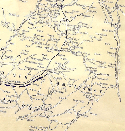
The District lies between 33° 50’ to 34° 23’ North latitudes and 72° 35’ to 73° 31’ East longitudes. It is bounded by District Mansehra on the North, District Haripur on the West and SouthWest, District Muzaffarabad of Azad Jammu and Kashmir on the east, District Rawalpindi on the South and District Islamabad on the SouthEast. To the East the River Jhelum and to the NorthEast the River Kunhar serve as boundary between District Abbottabad and District Muzaffarabad of Azad Jammu and Kashmir. The total area of the District is 1,969 Sq. KM.